x #05
Jul.06

|
Introduction
The idea of “Location awareness” and the mind-blowing ways in which a multiplicity of devices and technologies have materialized it, can be seen as the simple realization of the following:
“Where I am” is a pair of X and Y coordinates.
This positional system did not keep up with our referential systems for the 4th dimension as far as personal technologies go. Watches have been around for a long time. Nothing easier than knowing “when I am” – just look at your watch (or at your cell phone … I can’t remember the last time I asked the time and someone actually had a watch…). Now… “where I am” is a whole different deal. Sure I don’t need a GPS system to know- and report - that I am at the SuperComputer Center, UCSD, San Diego, California, US as I write this. So are 40 other folks attending like me the 1st conference on Cyber-Infrastructure for Humanities, Arts & Sciences. But I can get as precise as to say that my position in this room at a discrete point in time is unique to me. “Well… It is a question of approximation”, you will say. “You are roughly at some room at UCSD and that should be enough” . Not true: shouldn’t we be naturally progressing towards high fidelity rather than the other way around? Whether we want it or not is not the point here: our constant search for more precise ways of reporting position (and time, for that matter) is the inescapable consequence of the increase in image resolution and audio sample rate.
“Where I am” or at least my coordinates at high resolution/fidelity is a very personal piece of data and this is an aspect of locative media to which artists cannot be indifferent.
What is then, this “location-aware” generation? Howard Rheingold contends that spontaneous constellations of folks can almost instantaneously get organized and physically gather somewhere in the urban landscape [A]. These spontaneous clusters are often to protest – e.g.: against the US position regarding the Israel-Lebanon conflict, or the rise in gas prices – and always to voice community problems. Rheingold describes these as “smart mobs” and says that they will be key in social change. It looks like the “e-citizen” (I loathe this word…) may not be the user of an e-government portal that offers online payment of taxes but rather the product of a grassroots movement that includes mobile technologies, ubiquitous computing and open source code.
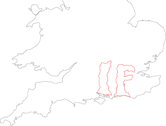
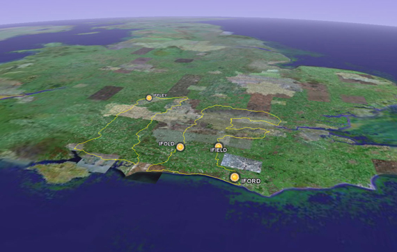
Location: Southern England, UK
Date: 21/08/02 Total Track Length: 863 km / 537 miles Method: Car
Source: GPSdrawing website, maintained by Jeremy Wood and Hugh Pryor
http://www.gpsdrawing.com
How this article is structured and why
There are applications of locative media in a diversity of areas and it would be impossible and totally useless to list them all. Rather, I want to pinpoint a small number of projects - some of them overlapping several areas - that can be inspiring for those working in locative media, wanting to start to work in this field or those who are simply curious about what is out there. I will stress projects that are (or have the potential to be) relevant to the community because I am interested in the leap from that personal, individual data to the data that relates to a community and have the potential to reshape it.
It is noteworthy that the research agenda for locative media – precisely because it screams for interdisciplinary approaches – is often beyond the mainstream academia.
Given what I wrote earlier then, I quickly gave up on what would have been a more classical approach of teasing the term “locative media” out of a tangled mess that includes augmented reality, mobile media, ubiquitous computing, GPS, and mobile media. I realized that that semantic mumble jumble actually illustrates several aspects of that which is “locative”: like augmented reality, it combines the real world with computer generated data… and like ubiquitous computing, its computation is embedded in the environment. GPS and mobile media can be seen as enablers of the locative. And as we did not have enough I even throw in the concept of “social sculpting” but will leave this one for later…
For now, let’s strip the concept down to this idea: behind “that” which is “locative” is the principle that location awareness is pivotal for the delivery of contextual information, whether the concern is with information accuracy, richness (as in integrated) or with its translation to another, innovative, context.
One last note on the bibliography – a major part of this article are personal reflections on the technologies implied and references to existing projects that are mostly online. That explains the short list of bibliographic references but the relatively long list of additional readings. These are the pivotal texts that informed my own reflections that I express her eand that I would therefore like to share with this community.
Why do locative media have affinities with the idea of community?
Locative marries the idea of mobile (“on the go”) with the notion of embedded in the real world. With locative media, community members don’t need the computer screen to experience interactive media – it surrounds them and it finds its referent in the physical place. Examples of areas that are community-relevant that are exploring this convergence are performance, games, and cultural heritage. And if games may not be immediately strike you as community-relevant have a look at the Games for Change website http://www.gamesforchange.org/ or at the very recent Times article that caused a brouhaha in the US given the current world situation with the self-explanatory title “Saving the World, one video game at a time” (article available online but by subscription only… extract available here http://pbokelly.blogspot.com/2006/07/saving-world-one-video-game-at-time.html and in an exponentially growing number of blogs and posts since the data of its publication, which was 4 days before the date of the present article [C].
Locative media projects:
Hypermedia Berlin
Developed at UCLA, Hypermedia Berlin is a web-based collaborative environment that proposes the overlay of cultural, architectural and historical layers of a city as a way to map it. You can try it at http://www.berlin.ucla.edu/ (Note: the points on the map marked with an S will bring up a window prompting you for a login and password that you do not have). You can explore the interface and see some of the wonderful graffiti of the once up Berlin wall if you click on one of the lower and right most hot spots.
The team lists the technologies used as follows:
· “Geo-referenced historical maps
· GIS enables database-queries and proximity locator
· Zoomify and time-space linking
· Micro-annotation and scholarly community editing”
Notice the last bullet… It is great – and rare - to see how the manual annotation is recognized as a technology. In fact there would be no Hypermedia Berlin if no actual content could be added.
http://www.berlin.ucla.edu/
The World's biggest 'IF'
Hugh Pryor and Jeremy Wood provided the answer to this question. The world’s biggest if is (sound of drums…..): the "I" that goes from the village of Iffley located in Oxford to Southampton and back, and the "F" that cuts through the Ifield Road in London down to Iford in East Sussex, then through Iford and back up again through Ifold (West Sussex). The artists decided to convey the height of the drawing of the IF pair in typographic units and that number is 319,334,400 point while the text you’re reading is approximately 10 point…
This project is an example of GPS drawing – a very creative use of global positioning systems that uses digital marking using GPS satellite navigation technology. These usually result in drawings that represent a huge-scale and often translate actual journeys captured with GPS devices. Additionally there may be other layers of information such as photos of the actual places of any other type of parameter relative to the place or to the individual “drawing it”. Pryor and Wood often identify how the data was collected (e.g.: walk, car)
http://www.gpsdrawing.com
Dialtones (locative?)
As the name implies, this is a piece on annoying cell phone ring tones. You register your cell phone number, you download special ringing tones and then you enter the space with a big mirror. The dial tones are activated by touching keys and an embarrassing light reveals the cell phone owner whose cell is producing the sound, who then timidly waves... You can hear an example of the audio produced in one of these performances at http://wfmu.org/listen.ram?show=5687
I hesitate about including this public art project under locative media – as I am not 100% sure of how the light tracks down the audience participant but I thought this is the example of a clever mix of mobile media, interface customization ( the downloaded ring tones as a new expression of the old stickers’ swapping) and with interesting aspects of distribution (what does it really mean to hear the audio file I mentioned before in the absence of the visual referent) and privacy (huh… who exactly am I giving my phone number to?...)
GPS Games
At the IMG Lab, part of CITI (Center for Informatics and Information Technology), of the Faculdade de Ciencias e Tecnologia of Universidade Nova de Lisboa, graduate students are working with Professor Nuno Correia on a prototype for a narrative and game that invites the player to interact with a fictional character that gives him/her information about the physical place: Quinta da Regaleira. This is a small portable device still under development that the visitors would carry with them as they interact with the physical space. The purpose is not to replace the exploration of that wonderful space but rather to offer new ways to explore information about it and at a later stage provide the possibility of collective walks where different visitors can interact with each other, and with the physical place. As I was told by one of Professor Nuno Correia’s student – Tiago Martins, on his way to the Ars Electronica (Linz) to pursue work in this area – during the development of the product they have been encountering interesting questions such as what are the best positioning technologies in inside and outside spaces. Also Rute Frias, the designer working in the project is concerned with the implications of the light conditions outside for interacting with a small screen. All these questions are providing a reality-check worksheet that will certainly improve the quality of the final product.
Yellow Arrow
Not sure how to label this one… but somewhere between public art, social game and digital storytelling. In sum: you buy big yellow stickers arrow-shaped (a sort of big post-its) from the www.yellowarrow.org website that contain a number code. You walk around your city and stick it at a place of your choice – that is meaningful to you (a good or bad memory), or that you simply consider as a city landmark. You use the code on your arrow to associate with the narration of your experience that you then instant message to a number you are given on the website. Days later the innocent “flâneuse” (borrowing - and “gendering” - Baudelaire’s term) who is walking on the streets of Lisbon sees a big yellow arrow pointing at the door of “A Brasileira” coffee shop. She instant messages the number she sees on it. She gets back:
“Here my father told me a great story I want to share with others: that of the Portuguese painter Vieira da Silva who would help her broke friend - the painter X - by drawing on paper napkins so that he could buy food with the money he would get selling her work (Vieira da Silva was already a well known and successful painter both in France and Portugal. I have always imagined how wonderful it would be to find one of these old paper napkins with Silva’s great work entangled with coffee stains[1] and how no digital medium would give me the same satisfaction”.
Yellow Arrow uses locative media and is at the border of public art, digital storytelling and social sculpture in the Beuyian’s sense of “how we mold and shape the world in which we live”[B]. It suggests a total new type of mapping that exposes the concealed (sometimes clandestine) layers of the city.
http://www.yellowarrow.org
“Can you see me now?”
“Can you see me now?” is one of the several mixed-reality games created and performed by Blast Theory, a performance group based in the UK . The name “Can you see me now?” is a satire to the line “Can you hear me now?” that invaded US households as part of a cell phone advertising campaign where a man is heard saying it from the most esoteric places to test signal reception. For Blast Theory, it is a way to involve online players who play from their homes and street players (Blast Theory team) tracked by satellites. There is a story script and an objective – and if you give your position away (while at home on your laptop) , game over… You die when a street player is within a given radius from you.
The group has performed this and other similar performances -all heavily entrenched in the urban landscape - in several cities of the UK.
http://www.blasttheory.co.uk/bt/work_cysmn.html
Implications of high fidelity
I can’t at this point avoid mentioning that I am as we “speak” at the SuperComputing Center of the University of California in San Diego where Larry Smarr just delivered a mind-blowing presentation about the Optiputer – the amazing screen he works with and looks at everyday at the EVL (Electronic Visualization Laboratory- University of Illinois at Chicago): it is equivalent to 50 Apple 30’’ Cinema Displays, which basically translates into 200 million pixels of viewing real estate! The Optiputer takes high resolution to a whole different level and suggests that unveiling the full potential of the “locative” must implicate interdisciplinary exchanges between artists, techies and social scientists willing to debate the consequences of adding extreme resolution to the encoding of the real environment [D].
Conclusions
In this short article on locative media I selected examples of projects that cover a variety of takes on that term, with a particular focus on those that provide the leap from the personal to the communal. From the examples chosen and taking into account the technologies the locative media relates to, it is clear that they must be studied across disciplines. Furthermore, it is fundamental that computer and social scientists start talking among themselves and with the Arts community to gain insight into the possibilities of these media in the creative industries. Last but not least, the research agenda is rich and open to exploration. Some questions are:
• What innovative cultural content can be made possible with locative media?
• How can we visualize data produced by sensors in networked environments? How from the point of view of the artist can you have an intervention in people’s location-awareness experiences?
• What special methods are being used by locative media researchers to evaluate their experiences? What are the strategies being used in devising those methods?
Location: Southern England, UK
Date: 21/08/02 Total Track Length: 863 km / 537 miles Method: Car
Source: GPSdrawing website, maintained by Jeremy Wood and Hugh Pryor
http://www.gpsdrawing.com
Bibliography
[A] Rheingold, Howard. Smart Mobs: The Next Social Revolution. Cambridge MA: Perseus Publishing, 2002.
[C] Thompson, Clive. “Saving the World, One Video Game at a Time.” New York Times, 23 July 23 2006.
[D] Larry Smarr, Andrew A. Chien, Thomas A. DeFanti, Jason Leigh, Philip M. Papadopoulos: The OptIPuter. Commun. ACM 46(11) -67 (2003)
URLs for the web-based projects mentioned (order: of mention)
“Hypermedia Berlin” http://www.berlin.ucla.edu/
“Yellow Arrow” http://www.yellowarrow.org
“The big ‘IF’ “ (an dother works by Hugh Pryor and Jeremy Wood) http://www.gpsdrawing.com
“Can you See me now?” http://www.blasttheory.co.uk/bt/work_cysmn.html
Audio file for one of the “Dialtones” performances http://wfmu.org/listen.ram?show=5687
Additional readings (order: alphabetical)
Belson, Ken. "In 'Smart' Hotel Rooms, Everything Is Just Right." New York Times, 16 November 2005.
Fukumoto, Masaaki and Mitsuru Shinagawa. "CarpetLAN: A Novel Indoor Wireless(-like) Networking and Positioning System." M. Beigl et al. (eds.): UbiComp 2005, LNCS 3660, pp. 1-18, 2005.
Hemment, Drew. "The Locative Dystopia" (2004). (Originally published in nettime: Fri, 9 Jan 2004 18:23:20 +0100 (CET)) and “Locative Dystopia 2" in Marc Tuters (ed.) + Rasa Smite, Acoustic Space: Trans Cultural Mapping (Riga: The Center for New Media Culture RICX, 2004).
Ito, Mizuko, Daisuke Okabe and Misa Matsuda, eds. Personal, Portable, Pedestrian: Mobile Phones in Japanese Life. Cambridge MA: The MIT Press, 2005.
Kwon, Miwon. One Place After Another: Site-Specific Art and Locational Identity (Cambridge, MA: MIT Press, 2004).
Manovitch, Lev. “The Poetics of Augmented Spaces – Learning from Prada” (2002) http://www.noemalab.org/sections/ideas/ideas_articles/pdf/manovich_augmented_space.pdf
Pope, S. “The Shape of Locative Media,” Mute Magazine Issue 29 (9 February 2005). Available online at: http://www.metamute.com/look/article.tpl?IdLanguage=1&IdPublication=1&NrIssue=29&NrSection=10&NrArticle=1477
Rogoff, Irit. Terra Infirma: Geography’s Visual Culture (London and New York: Routledge, 2000).
Tuan, Yi-Fu. Space and Place: The Perspective of Experience. Minneapolis: The University of Minnesota Press, 1977.
Wilson, Stephen. Information Arts: Intersection of art, science and technology (Cambridge: MIT Press, 2002) In particular 3.4: Space; 3.5: Global Positioning System.
[1] This is a true story that my father told me once when we were at the popular “A Brasileira” coffee shop in Lisbon. I would rather not name the broke painter but let me put it this way: he became such a recognized artist in Portugal and abroad that he may now be able to buy “A Brasileira”...
* Ana Boa-Ventura is finishing her PhD at the University of Texas at Austin. She is also a HASTAC fellow (read “haystack”… HASTAC= Humanities, Arts, Science, and Technology Advanced Collaborative) for National University in San Diego, California where she teaches hybrid courses on community digital storytelling. She has performed art installations and designed other digital artifacts that inform her research. Although her program is at the Radio-TV-Film Department of UT she is a Research Assistant at the School of Architecture where she works in the design of incentive mechanisms for collaboration in professional communities. For her doctoral dissertation she is looking at virtual communities for smoking cessation.
http://www.boa-ventura.com
|