INDEX>> A B C
Military sites in the United States A to Z.
Letter C (D will follow shortly).
This Journal is edited by the MOMS's Analytical Department. This Volume 3 is a special collaboration with the International Department.
Please contact us at moms@virose.pt
To subscribe/unsubscribe to the E-Journal of Modern Strategy please get this page
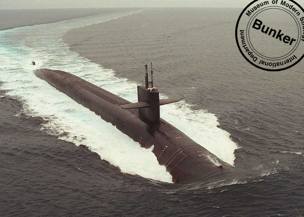
Camp Billy Machen Navy SEAL Training Facility
Camp Billy Machen is a new Navy SEAL desert warfare training facility, located on the edge of the Chocolate Mountains, next to Slab City, itself a former military base.
Location: Chocolate Mountains
State: CA
Camp Lejeune Marine Corps Base
A large Marine Corps base, surrounding the estuary of the New River, on the coast of North Carolina. The 246 square-mile (153,439 acre) installation contains live fire ranges, maneuver areas, landing zones, and parachute drop training areas. Home and training base for Marine Corps Expeditionary Forces, which make up most of the 41,000 active military at the base. There are almost 5,000 civilians working at Camp Lejeune as well. The New River Marine Corps Air Station, which flies mostly helicopters, is adjacent to Camp Lejune.
Location: 115 miles SE of Raleigh, five miles E of Jacksonville
State: NC
http://www.lejeune.usmc.mil/
http://www.globalsecurity.org/military/facility/camp-lejeune.htm
Camp Pendleton Marine Corps Base
One of the major Marine Corps bases in the country, located on the Pacific Ocean between Los Angeles and San Diego, with Interstate 5 traveling through its western flank. Training takes place by Army, Navy and Marine units throughout the rolling hills of the 126,000 acre base. Amphibious and sea-to-shore training takes place at several key points along the base's 17 miles of coastline. The main base is at Mainside, at the southeastern end of the base, and the remote northern interior is an impact area. Daytime population is around 100,000. The last major undeveloped portion of the Southern California coastline.
Location: 48 miles N of San Diego
State: CA
County: San Diego
http://www.cpp.usmc.mil
http://www.mccscamppendleton.com/
Camp Roberts
This 43,000 acre base in Central California is used by all branches of the armed forces, but is considered primarily to be a National Guard training base. The hilly interior is used as an aerial gunnery range by the Army. The installation is also used by various Defense organizations and civilian corporations for research and development and testing activities. There are over 1,000 buildings on the base, mostly built during the Korean War and WWII, when over 44,000 troops were stationed here. Fort Hunter Liggett, 30 miles away, is accessible to Camp Roberts by both highway and tank trail.
Location: 12 N of Paso Robles
State: CA
County: Monterey and San Luis Obispo
http://www.calguard.ca.gov/cprbts/
Camp San Luis Obispo
Camp San Luis Obispo is primarily a National Guard Reserve Center. The eight square mile restricted area covers mountainous terrain and serves as a training ground for several local, state, and federal agencies. The installation was once part of a federal Army post that extended as far as the ocean, five miles to the west, and accomodated as many as 20,000 troops during WWII. It is now a 4,100 acre, state-owned facility used by many organizations, from the Boy Scouts and police, to soldiers from area military installations, such as Fort Hunter Liggett and Camp Roberts. There are firing ranges, maneuver areas and two "mock villages" located in the rolling terrain of the base. Range operations are expected to increase in coming years, due to the closure of other California defense facilities.
Location: 10 miles W of San Luis Obispo
State: CA
County: San Luis Obispo
http://www.militarymuseum.org/CampSanLuisObispo.html
Cannon Air Force Base
Cannon Air Force Base, located in eastern New Mexico, is a 4,500 acre facility which has a population of over 10,000 people. Established in 1942, the base is now home for tactical fighter wings.
Location: 260 miles E of Albuquerque, seven miles W of Clovis
State: NM
http://www.cannon.af.mil/index.html
http://www.globalsecurity.org/military/facility/cannon.htm
Carlisle Barracks
Home of the U.S. Army War College, an advanced academic training institution, and a garrison of soldiers, which make up most of the base population of nearly 3,000. There are 217 acres of offices, classrooms, and historic structures near Harrisburg.
Location: 18 miles W of Harrisburg
State: PA
http://carlisle-www.army.mil/
Cavalier Air Force Station
Home of a large and unusual defense antenna, part of the Perimeter Acquisition Radar Characterization System (PARCS), used to identify and calculate the trajectory, and thus the impact point, of incoming missiles. This information is relayed to the underground command center in Cheyenne Mountain, Colorado. The antenna is housed in a large, monolithic structure at the Air Force Station.
Location: Concrete
State: ND
http://www.spacecom.af.mil/21sw/library/fact_sheets/10sws.htm
http://www.globalsecurity.org/space/agency/afspc.htm
Cecil Field Naval Air Station
This Naval Air Station was closed in 1999. Of the over 23,000 acres, including the Outlying Field Whitehouse, the Yellow Water Weapons Department, and the Pinecastle Electronic Warfare Range, which are located nearby, some has been slated for commercial development, while the majority has been transferred to the Naval Air Station at Jacksonville.
Location: 14 miles SW of Jacksonville
State: FL
http://www.globalsecurity.org/military/facility/cecil-field.htm
Chanute Air Force Base
A 2,125 acre Air Force Base now closed, and undergoing clean-up. Chanute was constructed in 1917 as a storage site and training base. Technical training continued until 1993, when all military operations ceased, and the base began to be converted to civilian use. Like many former military bases, portions of Chanute are contaminated Superfund sites.
Location: 14 miles N of Champaign/ Urbana, in Rantoul
State: IL
County: Champaign
Latitude / Longitude: N40 17.3100 / W88 8.3800
http://www.epa.state.il.us/community-relations/fact-sheets/chanute-afb/
http://www.epa.gov/superfund/sites/npl/nar1615.htm
Charleston Air Force Base
This Air Force Base covers 3,772 acres, and is one of three major airlift installations on the East Coast, flying military personnel and equipment to destinations all over the world using C-17's and other large cargo aircraft. Home to over 6,000 military and civilian personnel. It has an auxiliary airfield, the 1,400 acre North Auxiliary Air Field installation, located 85 miles north of the base, that is used for practice dropping.
Location: 10 miles N of Charleston
State: SC
http://www.charleston.af.mil
http://www.globalsecurity.org/military/facility/charleston-afb.htm
Charleston Air Force Base North Auxiliary Field
A WWII airfield, now used by the Charlestown Air Force Base, located 85 miles to the south. The 1,400-acre site has a fire station, and a few support structures, and is used as a supply drop zone for training purposes. It is also used by special operations as a training site.
Location: 85 miles NW of Charleston, one mile SE of North
State: SC
Charleston Naval Complex
When it was decommissioned in 1993, this major Navy shipyard had almost 20,000 workers. The facility is being turned over to the city, once the Navy has fully evacuated and remediated the site. New tenants are being sought.The complex is a heavily industrialized 1,500 acres with over four and a half miles of shoreline on the Cooper River, north of the city of Charleston. Also known as the Charleston Naval Shipyard, nuclear submarines were service here.
Location: N Charleston
State: SC
http://www.globalsecurity.org/military/facility/charleston.htm
http://www.globalsecurity.org/military/facility/charleston_nsy.htm
Cherry Point Marine Corps Air Station
Cherry Point is the largest Marine Corps Air Station in the nation, and is located on 11,700 acres on the coast of North Carolina, surrounded by the Crotan National Forest. In addition to being a major flight training facility, the base is home to a naval aviation logistics and supply depot. 16,000 people work at the base, including 11,000 military stationed there.
Location: 18 miles SE of New Bern
State: NC
Latitude / Longitude: N34 54.1400 / W76 52.8700
http://www.cherrypoint.usmc.mil/
http://www.globalsecurity.org/military/facility/cherry-point.htm
China Lake Naval Weapons Testing Center
A vast weapons development facility and testing range. Almost every munition in the US arsenal has been tested within this 1,723 square mile (more than a million acre) facility. Numerous laboratories and test ranges, located mostly in the north area of China Lake, support weapons development. In the southern portion of the reservation are electronic ranges that support training and weapons proving. China Lake is part of the Navy's Western Test Range complex, along with White Sands and Point Mugu. The base employs about 5,500 people, with an additional 2,500 more local contractors, and the annual budget is near $750 million. There are two major geothermal power plants and numerous petroglyphs located in the Coso Mountains on the north end of the reservation. Also in the remote northeastern area is the Junction Ranch radar cross-section range.
Location: 75 miles N of Barstow
State: CA
County: Inyo, Kern and San Bernardino
Latitude / Longitude: N35 43.2500 / W117 36.4900
http://www.nawcwpns.navy.mil/
http://www.globalsecurity.org/military/facility/china-lake.htm
Chocolate Mountains Aerial Gunnery Range
The Chocolate Mountain Aerial Gunnery Range is a 456,000 acre (about 60 square-mile) restricted area on the east side of the Salton Sea. It is used by the Navy and Marine Corps for aerial gunnery and bombing practice, primarily for aircraft based out of the Marine air station in Yuma, Arizona, and the Navy at El Centro. Navy SEALs also practice desert warfare tactics on the range. Administered by the Yuma Marine Corps Air Station.
Location: Imperial County
State: CA
County: Imperial
http://www.yuma.usmc.mil/Services/RANGE/Chocmtni.htm
Cold Regions Research and Engineering Laboratory (CRREL) Field Station
The field station consists of 135 acres of land and several small buildings. This isan area with ice-rich permafrost soils, so it is an ideal location for testing the response of pilings and other foundations to permafrost creep and frost-jacking. Nearby, in Fox, is the CRREL permafrost tunnel, a 360-ft horizontal shaft excavated in permanently frozen ground.
Location: Farmer's Loop Road, 3 miles NE of Fairbanks
State: AK
County: Fairbanks North Star
http://www.crrel.usace.army.mil/
Columbus Air Force Base
DTraining base for Air Force pilots, on 4,000 acres near Columbus. Basic jet flight training, using primarily Cessna T-37s, and Northrop T-38s. Employs around 3,000 military and civilians.
Location: 135 miles NE of Jackson, nine miles N of Columbus
State: MS
Latitude / Longitude: N33 38.3700 / W88 26.3800
http://www.columbus.af.mil/
Concord Weapons Station
Port Chicago is the name associated with the tidal portion of the 13,000 acre Concord Naval Weapons Station, the largest coastal munitions storage facility in the West. The site is in transition, with portions being transferred from the Navy to the Army, and Navy portions now administered by the Seal Beach weapons center in Orange County. The base is in three sections: the 7,648 acre tidal site, on the water, used for storage and loading; the administration/personnel area, on the south side of Highway 4, with barracks, equipment shops, recreational facilities, and offices; and the inland area, on the north side of Highway 4, with 5,272 acres for weapons storage, which has recently been emptied by the Navy. There are different loading systems on the shore, from a barge dock to piers with overhead cranes and rail access. Both the tidal area and the inland area are covered with around one hundred protected rail spurs for storing explosive laden train cars, called rail barricaded sidings (RBS). Concord has been known to be a nuclear weapons depot for decades, though it is the official policy to neither confirm nor deny their presence on site. A high-security "Q" area near the water, with 41 magazines surrounded by double fencing, and with its own guard station, is still in use. Port Chicago came to national attention in 1944, when the most powerful manmade, non-nuclear explosion in history occurred, killing 320 men who were loading a ship at Pier 1. The remains of the pier are visible today, and a memorial has been built recently on the site.
Location: 35 miles NE of San Francisco, E of Concord
State: CA
County: Contra Costa
http://www.sbeach.navy.mil/Info/Concord.htm
http://www.nps.gov/poch/
http://www.history.navy.mil/photos/pl-usa/pl-ca/pt-chgo.htm
Coronado Naval Amphibious Base
The West Coast hub for amphibious Naval operations, and host to tenant units, such as the Naval Special Warfare Command and the expeditionary Warfare Training Group. About 5,000 people work at the base, which hosts around 7,000 transient personnel each day as well.
Location: Three miles W of San Diego
State: CA
County: San Diego
http://www.nasni.navy.mil/
http://www.globalsecurity.org/military/facility/coronado.htm
Cutler Naval Communications Unit
Cutler is a relatively small and remote Naval facility with one of the world's most powerful transmitters. The VLF (very low frequency) antenna and transmitter station is a communications link between regular navy communications systems and ships and submarines in the North Atlantic and Arctic Oceans. The facility was built to prevent the disruption of communication that can occur in northern latitudes from Auroral effects. Unlike regular communications frequencies, VLF waves are not susceptible to these disturbances. The site consists of three locations, totaling 3,000 coastal acres, not far from the Canadian border. It was established in 1961, and has some remarkable features, including over 2,000 miles of copper wire underground and in the ocean. The two principal antenna arrays are composed of 26 radio towers, some almost 1,000 feet tall. Cutler has it's own power plant to keep the 2-megawatt transmitter running all the time. It employed around 300 people, until it was closed in the late 1990's. The site is now undergoing conversion to civilian use.
Location: 100 miles E of Bangor, 12 SE of East Machias
State: ME
http://www.globalsecurity.org/military/facility/cutler.htm
Main source : THE CENTER FOR LAND USE INTERPRETATION [http://www.clui.org/]
last update:Thursday, March 20, 2003
|