b #10
Jul.04
|
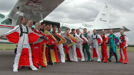
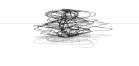
We collected the data from 19 jumps during an annual two-day wingsuit festival.
We also placed GPS receivers on the two airplanes that transported the jumpers from the drop-zone.
The pilots made wide spiraling tracks ascending towards the drop point above the airfield, and then made tighter squiggles as they sped down to pick up the next group of jumpers.
Some of the structures are about 12,000ft high and 10 km wide.
Location: Weston-on-the-green, Oxfordshire, UK
Date: 20-21/07/2002
Jump Altitude: 11-12,000 ft
___________________________________________________________________________
All the drawings have been made by traveling along the shapes and squiggles using Global Positioning System (GPS).
What is GPS Drawing?
Large-scale digital mark making using GPS satellite navigation technology.
In essence GPS Drawing is about recording lines using ones journey as a mark making medium.
The GPS receiver automatically records the route like a geodesic pencil.
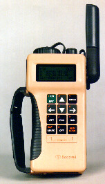 |
Precision Lightweight
GPS Receiver (PLGR)
|
A GPS receiver is a navigational device that reads precisely timed signals from a network of over 24 swarming satellites.
These signals are used to calculate its position on earth using trilateration. With four or more satellites in view it can used to determine a 3D position using latitude, longitude and altitude.
|